We invite you to take part in the inaugural Foot or Flybubble Challenge!
Using only your feet or your wing, link every SHGC launch site in the closed circuit. Any day in July counts, between sunrise and sunset. The best attempt wins (longest then fastest around the course).
It's like the X-Alps, only there's no Alps, and it's not nearly that X.
It's a great opportunity to learn about the Southern sites, to discuss the route choices, share tips, speculate and of course attempt your own inspiring flights and applaud your friends!
Foot or Flybubble. Are you up for the challenge?
Info
We invite you to take part in the inaugural Foot or Flybubble Challenge!
Using only your feet or your wing, link every SHGC launch site in the closed circuit. Any day in July counts, between sunrise and sunset. The best attempt wins (longest then fastest around the course).
It's like the X-Alps, only there's no Alps, and it's not nearly that X.
There's no need to run in the rain with a wet glider - you choose the day. Everyone can try it. But that doesn't mean it isn't hard, hairy and a whole lot of fun!
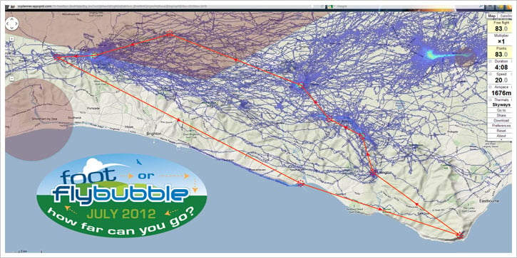
It's a circular route: you may choose any start site and direction, but no zig-zagging is allowed. Your tracklog must show you within 200m (horizontally) of each turnpoint. You are aiming to return to your start point before the day is done, which means the route is 83 km for everyone.
"Wow, that's huge," you say. Yes, but it doesn't matter if your attempt is a flop over the back from the Dyke, a humble ridge run at Bo Peep followed by a walk to the Trevor Arms, or even a float along the coast path from Beachy Head. Any attempt counts.
BestFlyingSites.com will sponsor a prize for the first pilot to bag the most sites in one day. Flybubble.co.uk will sponsor prizes for the best video clip, the best image, and the best write-up. The event winner will get a free meal at the prize-giving evening to be held on 4th August, where we'll present media from the challenge.
It's a great opportunity to learn about the Southern sites, to discuss the route choices, share tips, speculate and of course attempt your own inspiring flights and applaud your friends!
Just like the X-Alps, a supporter may bring you sustenance if you want (or you can pop in to the pub), but you must carry your active GPS and all your flying gear all the time. No motors or transport allowed. When you're all flown out and tired of walking, you can 'peg your flag'.
But you know someone might still be scratching along the cliffs at Newhaven... can you really afford to go home before the sun goes down?
Yes there are tough bits, that's what makes it interesting.
Foot or Flybubble. Are you up for the challenge?
HOW TO ENTER
Email your continuous GPS tracklog to [email protected]
Then try to capture the spirit of the challenge and post your story, image or video on the event page on facebook.
If you're not already a member of the SHGC, please join the club or make sure you pay your daily site fee. We can only accept entries from current BHPA licenced pilots following the usual flying rules. Club Pilots should buddy up with any rated Pilot on site to get a briefing and companionship on the route. You may fly any footlaunched glider you want. Yes, we welcome hangies; give it a try!
Even if you don't take part, you can learn a lot about the great SHGC sites, the personalities, the champions, the gliders and the ups-and-downs of cross country flying just by watching the event on Facebook.
JOIN US on FOOT OR FLYBUBBLE 2012
Turnpoints
T01 Beachy Head (50°44.390'N 0°15.180'E)
T02 High & Over (50°47.464'N 0°8.532'E)
T03 Bo Peep (50°49.226'N 0°7.712'E)
T04 Firle (50°50.061'N 0°5.179'E)
T05 Mount Caburn (50°51.686'N 0°3.049'E)
T06 Ditchling (50°54.174'N 0°7.010'W)
T07 Devil’s Dyke (50°53.132'N 0°12.746'W)
T08 Truleigh (50°53.048'N 0°15.648'W)
T09 Newhaven (50°46.926'N 0°3.002'E)
Adding the route and waypoints to your flight instrument
Important Note Regarding GPS Tracklogs: Most freeflight instruments are set up to only record flights, not walking. They automatically start to record a flight when you launch, then automatically stop recording once you land. This means you're GPS tracklog won't show any of the non-flying bits you do, so your efforts might not count for the Foot or Flybubble! You need to double-check whether your instrument(s) can be set to record the whole time, whether walking or flying. Most Garmin GPS' can be set to record continuously. You should also check that your GPS won't run out of tracklog points when recording for potentially 16 hours plus! At the end of the day it is up to the pilot to ensure that they have a valid tracklog.
How to download the route to your Garmin GPS
1. Download this GPX file (right click, Save link as) and place it in a folder on your computer.
2. Switch on your Garmin GPS. Then connect it to your PC.
3. Open http://www.takitwithme.com/gpx.html and follow instructions.
4. On your Routes page on the GPS, find the new route, rename it to FoF-2012 and activate it.
Mac users: See section "Foot or Flybubble for Mac users" below.
How to add the waypoints to your Flymaster flight instrument
1. Download this wpt file (right click, Save link as) and place it in a folder on your computer.
2. Download GpsDump from Stein Sorensen's website.
3. Run GPSDump and open the .wpt file. Connect your Flymaster flight instrument to your PC.
4. Choose the "Send to Flymaster (ID & Name)" option fro the "Wpts" menu.
Foot or Flybubble for Mac users
HOW TO DOWNLOAD THE ROUTE TO YOUR GARMIN (MAC)
Crispin Rose-Innes kindly gave us the following helpful tip for Mac users:
"Garmins have never easily synchronised with Apple Macs. However here's a way which works for us:
1. Download the old version of Firefox 10.0.2 from the web (search for "Firefox 10.0.2 download"). Once downloaded you'll be asked if you'd like to install the latest version - DON’T! You have to use Firefox 10.0.2 as later (or earlier) versions of Firefox don't support GiPSy Flight Manager, the Firefox add-on which talks to Garmin.
2. In Firefox 10.0.2, go to TOOLS in the header bar > WEB SEARCH and type "GiPSy Flight Manager". This should then automatically install and embed itself within Firefox below TOOLS, and appear as a selectable option.
3. Turn on your Garmin GPS and connect it to your Apple Mac computer.
4. Select GiYPsy FM from the menu in Firefox 10.0.2. Once GiPSy Flight Manager is launched it should recognise which Garmin GPS unit is running, and remember it for future use. You should now be able to upload routes with way points.
5. Open the route on XCPLANNER.
6. Click Download (right hand side) then Format>GPX.
7. Open http://www.takitwithme.com/gpx.html and follow instructions.
8. On the Routes page on your Garmin GPS, find the new route and activate it.
Easy! Not! Patience is required BUT it does work beautifully once you know how!"
Thanks Crispin!
Leg distances
Foot or Flybubble legs
3.41km Truleigh - Dyke
7.00km Dyke - Ditchling
12.67km Ditchling - Caburn
3.91km Caburn - Firle
3.35km Firle - Bo Peep
3.40km Bo Peep - High and Over
9.67km High and Over - Beach Head
15.07km Beachy Head - Newhaven
24.67km Newhaven - Truleigh
83.15km TOTAL
Advice
Some general advice to help you along your way...
Sites
Please read the excellent sites guide on the Southern Hang Gliding Club website before you go. Because we pay a fortune for access, everyone who flies here needs to join the club (annual/day member) before flying and be BHPA licenced. Please be considerate when landing out and choose empty fields without horses.
DEVILS DYKE
In a N, it's often soarable here from 8am, which means you can attempt to soar along to Truleigh and back. Pilots occasionally slopeland and relaunch along here without upsetting anyone. Stay well clear of the massive powerlines, where the wind venturis through the gully. Once past Fulking there are many fields for landing, and walking paths back up. From about 10am it should be getting thermic, and you can try the crossing to the Ditchling ridge via Newtimber. The back of the downs (south facing sheltered slopes) often work better than the north side (shady). If you want to be sure, wait until later (12noon) for the climbs to be lifting through the morning inversion, when you can decide to go for Newhaven, or Ditchling, depending on the drift and the presence of any Sea Breeze Front.
TRULEIGH
We are allowed to launch from in front of the radio mast, but I'd expect to fly across from Devils Dyke. If you can't, you haven't got much chance of going anywhere on the route.
DITCHLING
Often works later than the Dyke, and not as well. Sometimes it can be a right old sink hole, probably due to thermals releasing further north (sunny fields) or south (back of the downs). Probably best to hook this turnpoint and drop back a bit towards the coast to find the sunny slope thermals. Unless the ridge is working well. In strong N, the whole ridge is soarable, but then its tricky at the end of the ridge trying to cross to Caburn. Easier to fall back to the Dyke and try the route anticlockwise in that case.
CABURN
This is one of the hardest sites to start your Foot or Flybubble route from, because a SW wind will push you out of the course towards Heathfield. In SE conditions, you often find convergence at Caburn between the one seabreeze coming up from Newhaven, and the other coming from Eastbourne. If you're passing Caburn from the Dyke, the hills behind the site often work nicely (sheltered, sunny slopes).
FIRLE
Not such a good place to start, because you'll have to fly a long way into the NW to reach the Dyke. But you could fly along to Firle Beacon, where the best thermals are, and from there along to Bo Peep, then High and Over (only in light winds) and drift on towards Beachy, where you might be lucky and hit the Sea Breeze Front.
BO PEEP
A good start point that works early (9am) in a NE, allowing you to get established and test out the quality of the air by pushing forwards over the flats. Once you feel confident of being able to cross 5km of flats, drift along to Firle, then make the crossing to Caburn. Best done if you can connect with a seabreeze convergence from Eastbourne.
HIGH AND OVER
There's a little curved ridge behind High and Over (get up at H&O, drift over) that would work nicely in a NE as a bridge to Bo Peep, maybe with a short walk. And to the east the ridge in Friston forest is a good bridge too (if heading to Beachy in NE). We've walked along the top of it and it looks like a good thermal-cooking bowl with OK slope-landing options. Expect the S seabreeze to come through the H&O valley by lunchtime though (unflyable).
BEACHY HEAD
Such a great site with so little xc potential. The cliffs on the south side are dramatic, but they run out after a short distance and leave you with some tricky gaps to cross, or a downwind dash inland towards High and Over (if you can get high). If the wind is E (often earlier in the day, then swings more S) then the air comes off the sea, so tends to be cool and stable. Nice scenic soaring, but the only way to start here would be to drift towards Eastbourne (avoid the bird sanctuary bowl) and work light tricky thermals over shallow wooded slopes before getting up enough to run to Friston forest. This implies about 11am start, when the slopes are warm enough. The most likely way to complete this turnpoint is to walk it at dawn (a long walk to High and Over) or to use the Sea Breeze Front at midday, having flown in from one of the other sites.
NEWHAVEN
Not a good start point, but in the afternoon is often soarable. It prefers SE rather than SW, so it would be best to soar towards Brighton and land there. Which makes it the last leg of the route, getting back to the Dyke.
Airspace
On the northern leg between Devil’s Dyke-Ditchling-Caburn, stay below 4500ft. For the rest of the course, stay below 5500ft. Check your air chart!
Thermals
Look at the route on XCPLANNER and click on 'Thermals' until it says 'Skyways'. Those are past tracks in the area, helpful to identify lines that work well.
GPS
How to get your track log off your GPS without breaking it
1. Switch on GPS
2. Connect USB cable to GPS, then connect to PC
3. Open GPSDUMP (free download from http://www.gethome.no/stein.sorensen/body_gpsdump.htm Latest version)
4. Click Garmin (USB) or whatever unit you use
5. In the data dump area, scroll down and left click once on the first data point you want (look at date and time)
6. Scroll to the last data point of your continuous track log (hike and fly), SHIFT + left click to highlight the whole track.
7. Click ‘Save log’ (top right button). This is KML format, best for Foot or Flybubble. Add something memorable at the end of the file name, like ‘bopeep-footfly’
8. Select File>’Save in IGC format’ and fill in boxes.
9. In the data area, now isolate any flights you want to use for XC leagues. Your launches/landings are where your speed drops to zero. Repeat step 7 (this is best for SHGC league) and 8 (for UKXC league/leonardo/xcontest).
10. Email the KML file from Step 7 to [email protected]
11. Clear your track log on GPS, ready for tomorrow.
Prizes
Prizes for the most sites bagged in one day, best video clip, best image, best write-up, and of course the overall winner...
Flybubble staff (Greg, Carlo, Nancy and Simon) are not in the running for prizes. The videos and stories we produce are our event media. Although our tracklogs might count for the ranking, we will award the prizes to the best pilot outside the staff team. The prizes are a token of acknowledgement to add some bubbles to the satisfaction of completing your track for the challenge.
Most sites bagged
For the pilot who links the most sites in one day. If two or more link the same winning number of sites, the first pilot to do so wins. Your tracklog must show you within the 200m radius cylinder of the defined turnpoints. You will win a brand new copy of the Best Flying Sites of the Alps book (Deluxe edition - that's the hardcover and ebook) sponsored by bestflyingsites.com

Best image
We're looking for the best image that captures the spirit of the challenge. Post it on the Foot or Flybubble page on facebook. Only do so if you are happy to grant us publishing rights (so we can include it in our newsletter, website and other publications). The winning image will be chosen from the final cut by a pilot's poll on facebook. The winner will receive a £10 Flybubble Gift Voucher*
Best story
We're looking for the best short story (at least 250 words, no more than 1250) that shares the adventure. Post it on the Foot or Flybubble page on facebook. Only do so if you are happy to grant us publishing rights (so we can include it in our newsletter, website and other publications). The winning story will be chosen from the final cut by a pilot's poll on Facebook. The winner will receive a £20 Flybubble Gift Voucher*
Best video
We're looking for the best video clip (at least 30 seconds, no more than 5 minutes) that shows the adventure. To be eligible for the competition, you must include the event logo in the opening titles and this closing image

Post a link to your Youtube or Vimeo video on the Foot or Flybubble page on facebook. Only do so if you are happy to grant us publishing rights (so we can include it in our newsletter, website and other publications). The winning video will be chosen from the final cut by a pilot's poll on facebook. The winner will receive a £30 Flybubble Gift Voucher*
*Flybubble Gift Vouchers can be used towards purchasing tuition, tandems, trips and uh... tackle (i.e. gear) from Flybubble. They cannot be redeemed for cash and will be valid for 12 months from the date of the prize giving. All of our usual terms and conditions apply.
Four sites bonus
Any pilots whose tracklogs show they have stitched together 4 sites in one day during the Foot or Flybubble will win the South African Sites Guide book courtesy of www.bestflyingsites.com It's quite feasible (with a little effort). Ones to aim for are High&Over, Bo Peep, Firle, Caburn; or Truleigh, Devils Dyke, Ditchling, Caburn.
Outstanding achievement
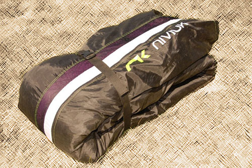
The pilot who really blows us away with an excellent performance given their experience. If you've never flown xc, this might just be getting away from the hill. For dusty old skydogs, you'll have to work harder. Basically, it will be the pilot who makes us go Wow! You will win a fantastic NKare bag from Niviuk UK.
Longest flight
The single flight of the greatest distance along the course (yes, one you can win without walking!). The winner will receive a £20 Flybubble Gift Voucher*
Longest walk
The longest total distance walked along the course line in one day (may be interrupted by a flight - we want you to try!). The winner will receive a £20 Flybubble Gift Voucher*
Overall winner
The pilot who makes the best attempt (longest, then fastest around the course) will be the winner. Your distance on any unfinished leg is calculated by subtracting how far you are from the next turnpoint in sequence from the leg distance, so you may deviate from the course but distance flown away from the course line adds no extra score. If more than one pilot completes the course, the fastest time wins. You must supply a 3D GPS track log of your attempt. The winner will receive £40 off their meal and drink bill at prize giving (yes you may spend it all on beer!)