
In the UK we fly near to clouds a lot, because the airmass is usually moist and the cloudbase is low. Small cumulus clouds can be fun, but large ones can become a problem. How can you tell the difference? Flybubble Greg analyses a recent XC flight that became a little too lifty...
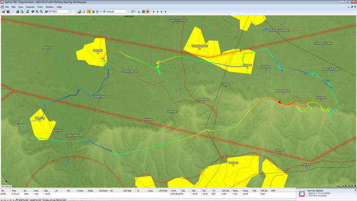
The day had a good flying forecast showing light winds from the NW, with an obvious line of sea air pushing in from the coast. Based on that weather forecast I'd set an ambitious 64km out and return flight, heading west from Ditchling (a low ridge facing the prevailing wind). I had not properly considered the clouds.
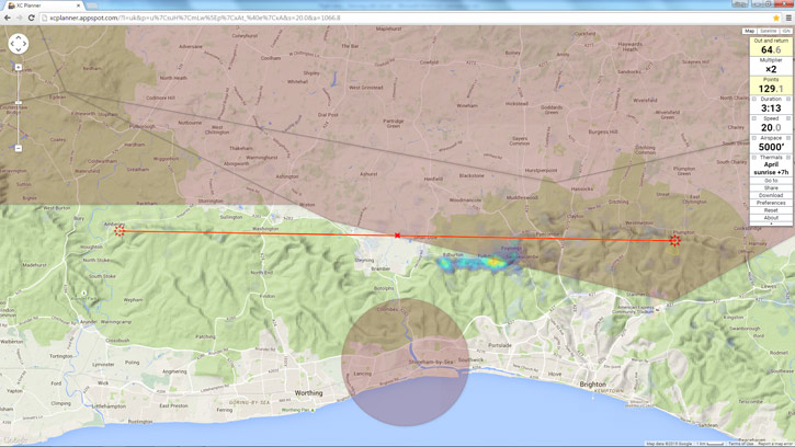
I expected to use the ridge as a thermal trigger, get up, then pass Devils Dyke (the coloured area, regular thermals!) before building height to cross the gap where the river runs to the sea. Then there's a fast run to Amberley with a useful ridge line to kick off thermals again, and a race back as the sea breeze starts to push in, which usually creates a (rather wobbly) line of convergence lift.
The danger point is the low ground of the Steyning gap, where on the return, the sea breeze is likely to push well inland - the higher ground of the ridge tends to slow its advance. So it would be important to climb high before the gap and fly over the top of this tongue of stable air, hopefully connecting climbs in the shelter of the Devils Dyke ridge again, possibly having to move even further inland on the advancing seabreeze front to make it back to Ditchling.
The airspace restrictions are fairly simple - a ceiling of 4500ft ASL from Ditchling to the Dyke, and further north, a 2500ft ceiling (very low). The bit shown 'in the clear' actually has a 5500ft ceiling, I just set the filter a bit lower on the XCplanner screen. There's also Shoreham airport (from the surface up to 2000ft), that pink circle near the sea.
Having spent most of the morning scratching in weak lift on the ridge, when I finally hooked a climb and got up, I wanted to stay near cloudbase. This was just over 4000ft, which gave me no margin for error - I couldn't afford to get lifted into the clouds, or I'd be in the 4500ft airspace. (For those who think in metres, that's only 150m to spare).
This is when flying a high-performance two-liner can be a real disadvantage. It's not possible to pull effective big-ears on the Icepeak 6, and there is no way to B-line stall it. The only option to lose height is a high G spiral dive. So I looked at the clouds very closely to identify the strength of the lift feeding them.
Some of the clouds were forming big chunky blocks around me, but as there was still plenty of sun on the ground I wasn't concerned because there were many gaps to skirt (sunny gap = sinking air).
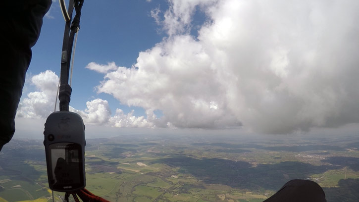
Looking ahead, there was a nice set of cumulus clouds to hop upwind.
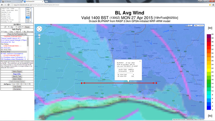
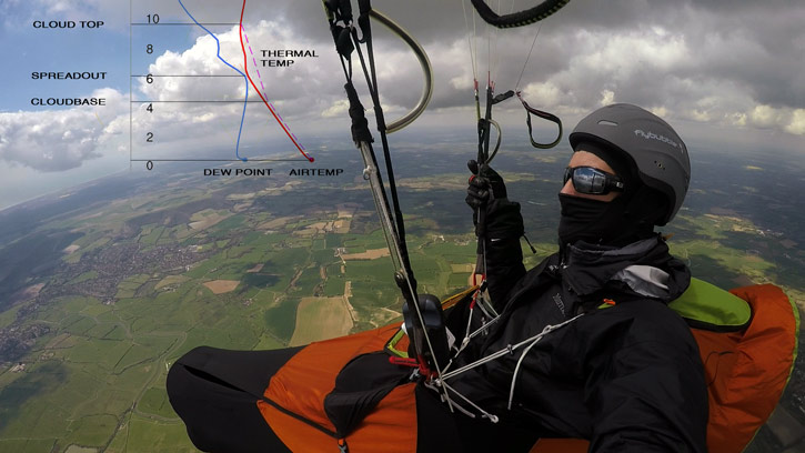
Let's consider what's going on here a little. Warm air (with evaporated moisture from the surface) is rising due to buoyancy, expanding as it rises, causing cooling. When it reaches its own dew point temperature, the moisture condenses, releasing latent heat (things get cool when water evaporates, the reverse happens when water vapour condenses). The thermal continues to get this boost all the way up inside the cloud, until it reaches air that is the same temperature. We can see where that will be by looking at a tephigram. I've used a station upwind of the site for the closest approximation.
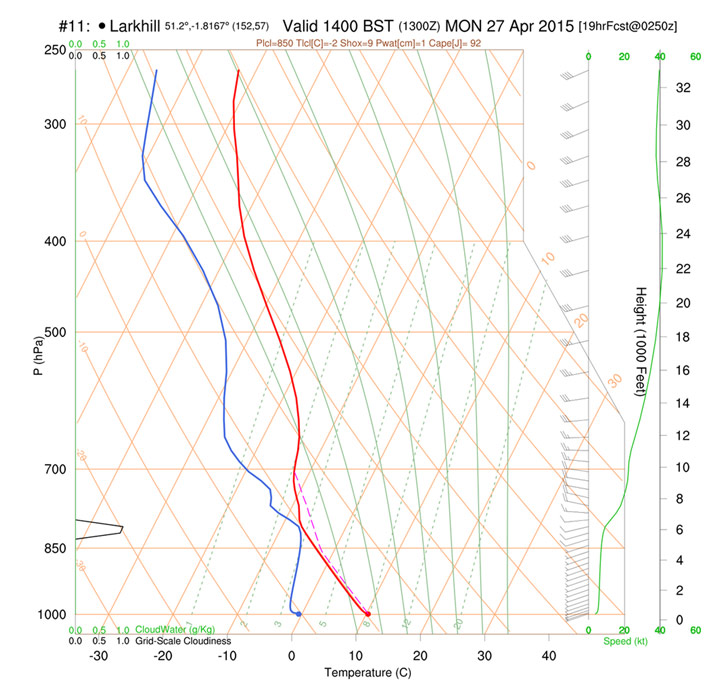
The solid red line is the air temperature that I would feel when gliding (outside the thermals). The dotted red line is the air temperature inside the thermals - basically, if there's a positive difference (it's off to the right), it goes up because it's buoyant. In this case, it's going up to 10,000ft which is pretty substantial, and in my case, way up into the London Gatwick airspace. A cloud with that kind of depth can generate large areas of sustained lift. And there's another problem with this tephi...
The blue line is the dew point of the air outside the thermals. If it touches the red line, it means that the dew point and the air temperature are the same - and everything at that altitude will be cloud. You can see that it won't take much for the whole sky in this picture to become overcast. It's too easy for the cumulus clouds to spread out sideways and link up, obscuring the strongest cumulus cells I'm trying to avoid. The spreadout also causes more latent heat release and for a while, a large area of sky will rise.
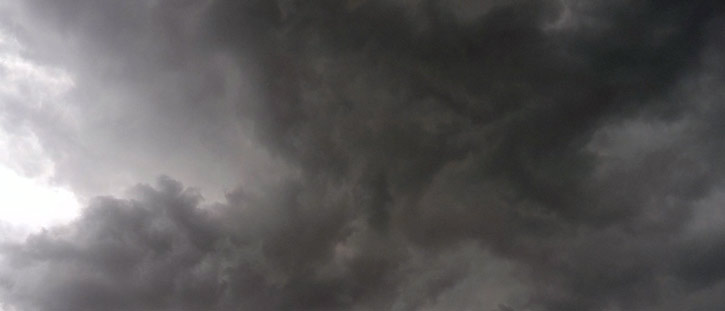
Looking ahead, I could see signs of the seabreeze front pushing inland. Can you see the saggy-bottomed cloud on the left with a base much lower than the rest? That's a wall of sea air that is bumping up against the prevailing offshore flow. The air from the sea is more moist and cooler, hence the water vapour condenses sooner, at a lower altitude.
Now remember that the airmass I am flying in is critical: it's close to becoming all one cloud. Push in a bulldozer of cool dense air from the coast, and you can see where this is going. At this point I was roughly half way around this track, gliding towards Steyning, with the planned turnpoint a long way off to the west.
The glide over Steyning was just too good. Beep beep beep there was continuous lift, and I couldn't see the extent of the cloud that had drifted in overhead. Staying out of the cloud meant veering SW, but this forced me into the sea breeze front. And then, kaboom, the lift went to 5m/s, and the cloudbase dropped.
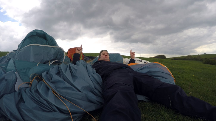
Spiralling the Icepeak hard and hearing creaking noises from my lighweight harness, I had to laugh at myself. I'd spent half the day fighting to get up, now it looked like I'd spend a long time fighting to get down. I went as tight as I could and still comfortably retain awareness, and my sink rate went to -6m/s, so the lift must have increased to 8m/s (in still air my spirals are around -14m/s). Round round round. I lost height, swung out and turned tail. There was no way I could go west, through that beast. I was too late.
Gliding back left me with a similar problem. The sea air was moving inland, and I needed to glide smack on the convergence line to reach my car. After a transition, I did a few turns to regain a working altitude, but very soon I was in the same hairy position - spiral-diving on my high-performance wing and groaning against the G force. This time I wound off 1000 ft below cloudbase before gliding off, where I achieved a standard downwind glide - there was no interference from cloudsuck.
Once on the ground it was easier to see the scale of the spreadout along the convergence line.
Some pilots were caught out by the sudden lift: there were tales of being sucked up inside cloud while on big-ears and full speedbar, and someone was even snowed on. Luckily everyone came down to earth safely.
Learning points:
* If the forecast shows cloud spreadout is likely, be careful of convergence, because it can switch the system into overdrive.
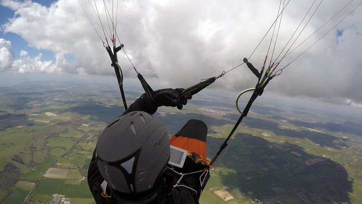
* Look out for signs of a stepped cloudbase (below, left) especially when there are indications that clouds can develop vertically (centre, above my hand).
* If you're going to use the lift under the cloud, shift over to the side where there is open blue sky (sinking air) so you have an escape route close by.
* If the clouds have more than 3000ft vertical depth and have crisp cauliflower tops, expect the lift to increase within 1000ft of cloudbase (cloudsuck).
* If the lift is widespread and seems too good to be true, it probably is.
© Flybubble.com