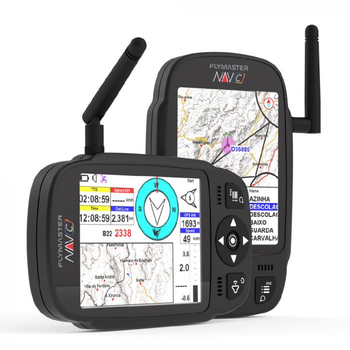
Flymaster NAV C: COLOUR SCREEN GPS ALTI VARIO WITH OPTIONAL FLARM MODULE
Overview*
- 72 channel U-blox BeiDou, Galileo, GLONASS, GPS / QZSS
- Ultra-sensitive Vario
- Built-in Flarm Beacon (no additional subscription needed)
- USB Type-C Mass Storage Access
- Improved data fields
- New User Interface
- Cutside View
- NEW Flymaster Instrument Manager Software
- Optional Flarm Obstacles Database
- In-instrument Flight Playback
- Flarm Aware Radar (optional feature)
- Extended Battery Life
- In-flight Voice Assistance
- Fully Customizable Layouts
- Highly visible under direct sunlight
- Altitude limits in task definition
- Extra-large Fonts
- Optional Bumper Case
- U-blox Bluetooth Low Energy
- Lastest Gen Microprocessor
- Anti-theft System
- High-resistance Protective Lens
- Glove-friendly Keys and UI
- Compatible with our Android and IOS App
- USB-C to USB-C Connection
- Data transfer over BLE to other Apps
Tech Specs
Main Hardware Characteristics
|
Display Type
|
Reflective colour 640x480px
|
|
Autonomy Learn more
|
Usually more than 24 hours (environment conditions may alter this value)
|
|
Size
|
152x90x18 mm
|
|
Weight
|
220 g
|
|
GPS
|
72 channel U-blox BeiDou, Galileo, GLONASS, GPS / QZSS
|
|
Native USB Connection
|
USB Type-C Mass Storage Access
|
|
Battery Charging
|
From wall adapter or standard usb port
|
|
GSM
|
Global Multi-band LTE-M
|
|
Bluetooth
|
Bluetooth 5 low energy module
|
|
Flarm
|
Flarm ready (optional Flarm Aware RX + TX mode)
|
|
Micro SD
|
Supports SDcards up to 256 GB
|
|
6 Axis accelerometer and magnetometer
|
Allows 6-degrees of freedom Tilt-compensated Compass)
|
|
Firmware update by USB (upgrades are free)
|
Battery type and capacity
| Battery Type |
Lithium-ion (Li-ion) |
| Battery Capacity |
6000 mAh |
INTERFACE FEATURES
|
User definable pages (each page can be draw using Flymaster Instrument Manager, and include a number of elements only limited by space).
|
8 page sets
|
|
Configurable graphical elements (depending of the element several parameters can be set by the user ex. Size, Border, Color, …)
|
15
|
|
Configurable data field elements (User can change size, border, title, Font, Color, …)
|
85
|
|
Page Trigger Events (page switches automatically if a specific event occurs)
|
• Airspace warning
•Entering thermal
•Transition (leaving thermal)
•Arriving at turn point
•Start opened
•Power up
|
|
Interface language
|
English
|
|
Configurable voice alerts
|
• Airspace
•Turn point complete
•Start opened
•Goal Possible
•Distances
•Countdown time
|
ARIOMETER/ALTIMETER FEATURES
• Buzzer/near thermal sound
• Ultra sensitive Variometer with 10 readings per second and 10 cm resolution
• Configurable vario digital filter and integration values
• Fully configurable Vario Sound (frequency, increments, frequency/vertical speed relation,….)
• Adjustable Sound Levels
• Automatic mute, keeps vario silent until takeoff
• Altitude adjustment using QNH
• Automatic altitude adjustment from GPS
• 2 independent altimeters
MEMORY FEATURES
• 3D flight logger IGC format
3D AIRSPACE
• The map offers an intuitive visualization of restricted areas, ensuring easy identification and awareness of prohibited zones.
• Adjustable voice warning of vertical distance to a restricted area
• Adjustable voice warning of horizontal distance to a restricted area
• Display of shortest vertical, and horizontal distance to restricted area
• Restricted area voice alarms (Altitude imminent, Position imminent, Violation, …)
• Critical Airspace page (displays information about areas that are closer than a defined distance)
• Airspaces browser
• Worldwide Airspace database
MAPS
• Detailed colored maps with topographic data
• With configurable layers
CROSS COUNTRY FEATURES
• Exclusive Thermal Ball indicator
• Several specific data fields like distance to take off, current and average glide ratio, average speed, etc.
• Distance to last thermal indexed with altitude
• Goto waypoint
• Multiple waypoint route
• Wind Speed and Direction (GPS based calculations)
• Automatic altitude gain profiler
• Nearby Landings (displays required glide ratio and distance to all the landings which can be reached)
COMPETITION FEATURES
• Route Optimization (indication for shortest route point)
• Speed to Start (optimal speed to make the start)
• Arriving altitude at next waypoint and goal (considering wind)
• Several Glide Ratios (to goal, average, to next,…)
• Easy task definition
• Task Navigation, configurable safety/risk margin on turn points.
• Task Map (trace with thermal indication)
INTERFACING
Compatible with MacOS (10.13 and higher), Windows (7/8/10)


