We are delighted to offer you Flybubble Weather, the innovative online free-flight forecasting tool developed by Caedmon Mullin and the Flybubble Crew. It's designed to get you more airtime by making the flying decision simple.
You wanted more airtime - here it is! Flybubble Weather is a free soaring forecasting tool that simplifies your planning for a great day up in the sky. Pick the right day to go paragliding or hang-gliding. Get to the right site. Find more flying.
Currently supporting only the UK and Ireland.
Fly more, with less!
Flybubble Weather has been created to help free-flight pilots fly more, with less.
Less complication. Less time. Less waste. Less frustration. Less friction with family, friends and work. Fewer wasted journeys and unfruitful visits to sensitive flying sites. Less pollution. Less wear and tear on your vehicle - and your sanity!
Save time, money and nerves whilst also benefitting the environment - and the free-flight community!
How it works, for you
Flybubble Weather is built using the RASP (Regional Atmospheric Soaring Prediction) forecasts, created by meteorologist Dr John W. Glendening, known as "Dr Jack". Thanks go to Dr Jack and the whole RASP community.
The unique aspect of our system is that it knows the range of "flyable" conditions at each flying site. The criteria can be updated, so the forecasts will improve over time to provide a reliable match between the forecast model and what really happens on the sites.
NB: While we do our best to make sure the forecasts are as accurate as possible you should always assess the conditions when you arrive at launch and decide for yourself if it's safe for you to fly.
Designed for all free-fliers
Flybubble Weather has been designed for paragliders, paramotors, mini wings, speed wings and hang gliders.
To allow for the different average flyable wind speeds for each wing type, you can set your wing type.
NB: Pilots must only ever fly sites they have permission for. For example, due to their engine noise, powered aircraft like paramotors are not usually allowed to fly from the same sites as unpowered aircraft. Doing so will likely endanger the site!
Limitations
The website only shows flying sites that are open to both hang glider and paraglider pilots. Some restricted, hang gliding only flying sites are not listed, so you'll have to make your own judgement about them. Checking nearby flying sites that are flyable in similar conditions can help.
NB: The inclusion of a site on our website in no way gives you permission to fly it, for site info find the local club.
Getting started
Visit flybubble.com/weather to get started.
Happy flying!
Tip: To make a shortcut for your mobile phone, tap on Menu (top right) and tap Add to Home Screen. For your PC, try Bookmarks (Add New) or Settings (Startup: Open Current Page) or keyboard shortcut Ctrl+D.
Instructions
Flybubble Weather has been designed to be as intuitive and user friendly as possible. However there's a lot more to it than first meets the eye! To help all users get the most out of what Flybubble Weather has to offer we've provided detailed instructions below.
Overview page
As the name suggests, this gives an overview of the flying sites and soaring forecast for the displayed area. For example

NB: The inclusion of a site on our website in no way gives you permission to fly it, for site info find the local club.
For your convenience, the website uses one of either your device location or the last flying site you visited on the site to centre the map, if your web browser allows it.
This page can also be used to quickly and easily find flying sites, and access the flying site pages.
Find flying sites
You can find flying sites in two ways:
- Search
- Flying site pins
Search
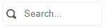
Start typing the flying site name in the search box. Suggestions will appear below as-you-type.
Select the flying site you want from the dropdown.
Tip: If you enter a site name in the search box and it doesn't appear in the dropdown then either the spelling we have differs (we use the club site name) or it's not in our database. Try different spellings or finding its pin on the map.
Flying site pins

Pan and zoom the map to find the pin for the flying site you want. Click on its pin.
Either of these will take you to the flying site page.
NB: If you think a flying site is missing that should be included, see the 'Feedback, requests & bug reports' section below.
Set your wing type
Use the Wing Type toggle (hang glider and paraglider icon buttons beside the search box) to set to your preference (light blue), to reduce the chances of a wasted trip (blown out or too light).

Select the paraglider symbol for paragliding on full size paragliders or flying larger mini wings.
Select the hang glider symbol for hang gliding or flying smaller paragliding mini wings or speed wings to increase the flyable wind ranges (14-33 km/h RASP).
Set the day and time
By setting the day and time (top dropdown boxes) you can quickly jump around to check up to 5 days ahead.
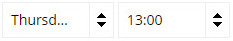
Tip: You can also advance the time by an hour by clicking on the map (avoiding the site pins). This works both on a non-touchscreen PC and a touchscreen device, such as a smartphone or tablet. On a PC you can advance or retreat the time using the left and right arrow keys.
Set the wind speed units
Set your preferred wind speed units:
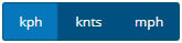
- km/h = kilometres per hour
- knts = knots
- mph = miles per hour
Map: flying sites (pins)
The map shows the flying site pins overlaid on Google Maps. For example:
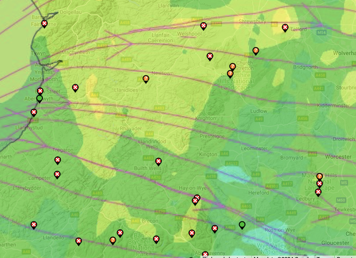
The flying site pin colour indicates whether it's expected to be flyable (or not):
- Green means it's expected to be flyable.
- Orange (?) indicates marginal flying conditions.
- Red (x) means it's not expected to be flyable.
Colour Blind Accessibility - Our new site marker pins make it easier to tell if conditions are good or bad as it's no longer just green, orange or red. If it's got an "x" in it you know it's no good, a "?" and it's worth a look - otherwise it's green and looking flyable!
Marginal flying conditions could be due to top-end wind strength—at 10 m AGL or aloft—or very low cloudbase, for example. For more detail see the section 'Low cloudbase or strong winds aloft?' below.
Zoom
Zoom the map in and out using the plus and minus buttons, bottom right:
![]()
Tip: You can also zoom using your mouse wheel (hold the Ctrl key and scroll the mouse wheel up and down to zoom in and out) on a PC, or your fingers on a touchscreen device such as a smartphone or tablet.
Pan
On a PC, you can pan the map around either by left mouse button click and hold anywhere on the map and drag, or right click anywhere on the map and then use the arrow keys.
On a touchscreen device such as a smartphone or tablet, use your fingers and follow the on-screen instructions.
Toggle full screen view
Toggle the map full screen view using the hatched square icon, top right:

Map overlays
The map can be shown with one of two overlays: the default is 'Wind at 10m'; the other is 'Stars (thermals)'.
Map overlay: Wind at 10m
By default the map shows the 'Wind at 10m' overlay. For example:
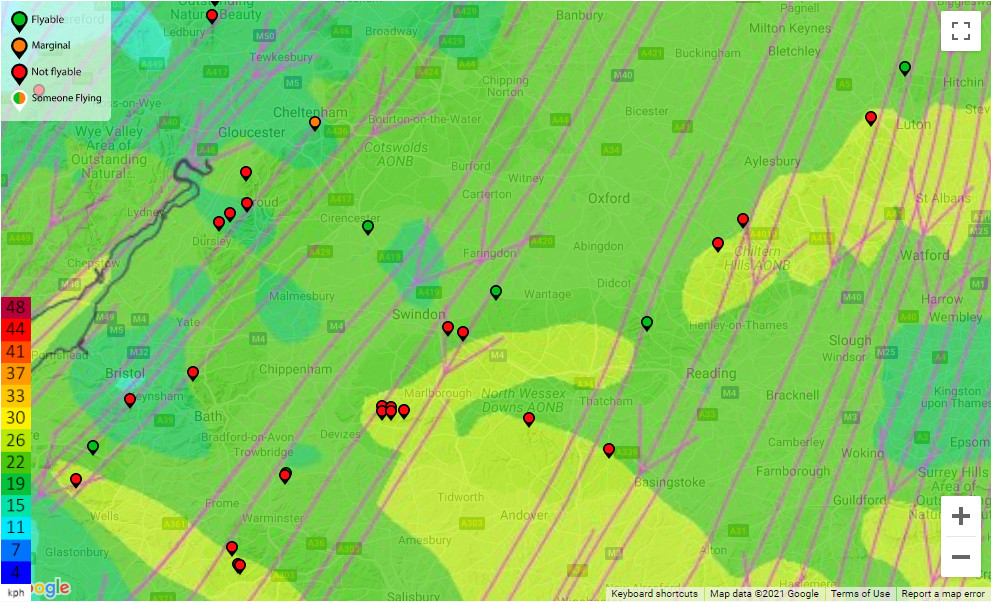
The lines and arrows indicate the forecast general air flow and wind direction at 10 metres (30 feet) above ground level (AGL).
There is also a coloured key to indicate the wind strength, bottom left.
Wind strength colour scale
The colours indicate the forecast wind strength:
- Lighter blue to darker green usually means good for soaring on paragliders.
- Darker blue is very light--probably too light--for soaring.
- Light green is top end (breezy) for paragliders.
Anything above that (yellow, red, dark red) means blown out for paragliding.
Map overlay: Stars (thermals)
Clicking the 'Stars (thermals)' button changes the map to the forecast thermal strength overlay. For example:
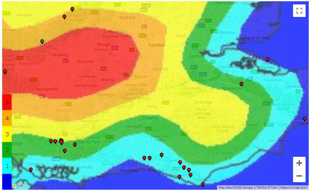
This is based on the thermal probability and modified by the foot launched preference for lighter winds. It gives you a quick overview of the expected thermal strength in different areas.
Thermal strength colour scale
Dark blue (lack of colour) indicates no or negligible thermal activity forecast.
If any thermal activity is expected then there's a 5 scale to indicate their forecast intensity:
- Light blue, very gentle thermals.
- Green, gentle thermals.
- Yellow, moderate thermals.
- Orange, moderate to strong thermals.
- Red, strong thermals.
Thermal strength: what's good for me?
Stronger thermals are good for getting high and going XC but also indicate stronger turbulence.
So, whilst a hotshot XC hound, focused on flying big distance, might want to see orange or red, a pilot wanting more predictable, smoother, safer flying conditions might prefer to see yellow, green or blue.
Airspace and NOTAMs buttons
It's also possible to display airspace or/and NOTAMs on the map and download the current airspace/NOTAM selection, ready to add to your flight instrument. For more info on this see the 'Airspace & NOTAMs' section below.
XC Planner button
We've also integrated Tom Payne's XC Planner app into Flybubble Weather, on both the overview page and flying site pages. For more info on this see the 'XC Planner' section below.
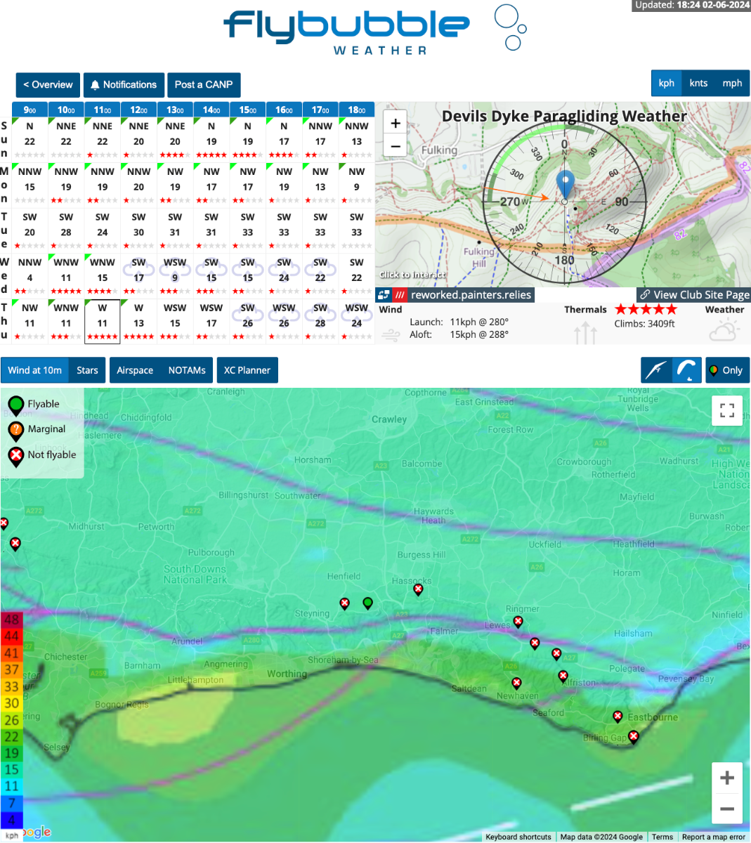
Flying site pages
The individual flying site pages give more detail for each site. For example:
NB: The inclusion of a site on our website in no way gives you permission to fly it, for site info find the local club.
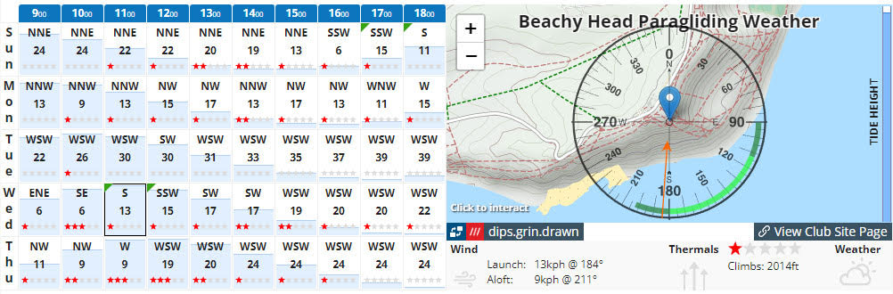
Soaring forecast table
The soaring forecast table shows the next five days at a glance. For example:
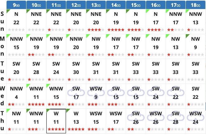
- Rows are the days. Columns, the time of day.
- Green ticks mean flyable. Light green indicates ideal. Dark green means marginal.
- Cardinal letters indicate the wind direction, based on a 16-wind compass rose.
- Red stars indicate thermal rating. No stars, no thermals. 5 stars, strong thermals.
- Weather. If it's forecast to rain then a cloud and rain icon watermark appears in the box.
Click on a time box to update the rest of the page and synchronise the info.
Tip: Occasionally, if the forecast data is currently being updated, the map overlays will look 'a bit off' - you'll notice the coastline doesn't line up. Check back in a few minutes for the latest info.
Site topo map & key data
The topography map shows the main launch site and range of directions that are ideal (bright green) and possibly still flyable (dark green). For example:
Just below the topography map, key site data is shown
Key site data
- Launch is the wind strength and direction at 10 m AGL.
- Aloft is the average wind strength and direction in the thermic 'boundary layer'.
- Thermals is thermal star rating (strength).
- Climbs is the likely top of your thermaling climbs, based on 'Ht of Critical Updraft Strength' (see RASP for more info).
- Base is the anticipated cumulus cloudbase.
- Weather indicates the likelihood of rain.
Tip: Comparing the wind at Launch to that Aloft helps you to judge if there is potentially dangerous wind above the site, or a big direction change (likely shear turbulence).
Tide Times
This has been one of our most popular latest updates. We now show tide times for all coastal sites, helping you pick the best time to visit your favourite coastal soaring spot! Tide times are shown by both the blue fills in the soaring forecast table, and the blue tide height bar on the right hand side of the topography map.
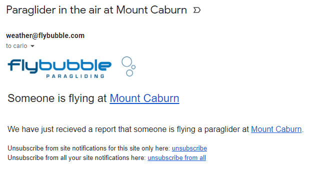
Anybody flying?
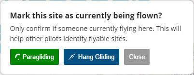
To help other pilots identify flyable sites, we've added the ability to mark each site as currently being flown, and whether they're flying a paraglider or hang glider.
If someone is currently flying at a site, go to its page and click the blue 'Anybody flying?' button.
![]()
This will bring up the 'Mark this site as currently being flown?' box.
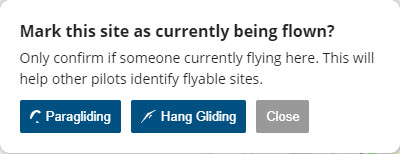
Now select either Paragliding or Hang Gliding.
The blue 'Anybody flying?' button will change to a green 'Flying' button, with an icon for the type of wing flown, and the map site pin outline will change from black to white, to indicate someone is flying.
![]()
Flybubble Weather will also send anyone who has subscribed to receive email notifications for this particular flying site an email for this (see the Notifications section).
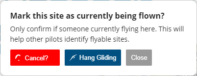
If you click the green 'Flying' button this will bring up the 'Mark this site as currently being flown?' box, with either Paragliding or Hang Gliding in green.
If everyone has stopped flying then clicking the activated button will cancel it, and the site will stop showing as currently being flown.
Notifications
To receive email notifications for each flying site, go to the site page, click the 'Notifications' button.
![]()
This will bring up the 'Get email notifications for this site' box. Enter your email address to subscribe.
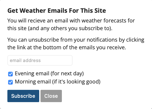
You can now subscribe to receive evening and morning email notifications for each flying site, letting you know which of your bookmarked sites are looking good. To receive these, go to the site page and click the 'Notifications' button. The evening one is a great nudge to get planning and book tomorrow off work!
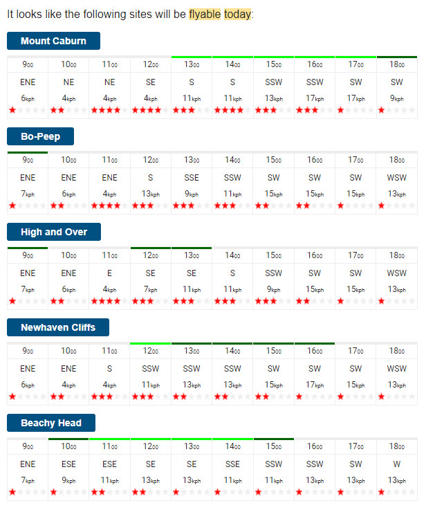
If any of the flying sites you've subscribed to are looking flyable that day, Flybubble Weather will send you a neat digest email with a full day forecast for each site, and links to each site page to quickly get more detail. For example:
If someone reports someone is flying at any of the flying sites you've subscribed to, Flybubble Weather will send you an email notification for this too. For example:
You can unsubscribe from your notifications by clicking the link at the bottom of the emails you receive.
Embed a site on your website
You can embed a one day soaring forecast for each flying site on Flybubble Weather on your website, including a convenient link to the full 5 day forecast including RASP maps on Flybubble, FREE!
For example, for Devils Dyke near Brighton in the UK it looks like this:
NB: To be able to do this you need to know how to embed HTML code on your website. If you don't then it's probably best to contact your webmaster and ask them to do it for you or show you how.
If you know how to embed HTML code on your website then go to the flying site page and scroll down to find the section 'EMBED THIS ON YOUR WEBSITE'. Click on the blue 'Get Embed Code' button, which will open a box with the HTML embed code highlighted inside. Copy this code to your computer's clipboard and paste it where you want it to appear on your website. Voila!
Other
For explanations about other features—e.g. the km/h, knts and mph buttons, the map and controls, and Wind at 10m and Stars (thermals) buttons—see the relevant subsections of the 'Overview Page' section above.
For info about the Airspace and NOTAMs buttons see the 'Airspace & NOTAMs' section below.
What decides if it's "flyable"?
Each site has a range of wind speeds and directions that we have been told it is flyable in (until we are told otherwise, these default to 7-25 km/h with an ideal range of 11-21 km/h).
These parameters are set relative to the forecast wind (on RASP) and not the real wind on site. In other words, if RASP says NW at 20 km/h, is it likely to be flyable at the site?
Small sites are generally considered ‘flyable' only when there is some wind. This also avoids the potential wasted time of going to a site with very light wind that changes direction.
Large sites where it might be possible to soar a cliff or glide to a thermal, might be ‘flyable' with less wind.
If all the required criteria for a site to be deemed flyable are met e.g. the forecast wind and weather data are within the site parameters, it will shown as flyable (green).
NB: We use the common parlance term "flyable" only to mean that it might be "possible to fly" for someone and not that it will be "safe to fly" for everyone. When a site is forecast to be "flyable" this simply means that, based on the given weather forecast and flying site data, it looks like it will be "possible to fly" for someone. In no way does this mean that it is or will be "safe to fly" for everyone. As every pilot should know from their basic flight training, whether it's safe to fly or not depends on many factors e.g. the actual wind and weather weather, site specifics, pilot experience, pilot skill, pilot state and pilot currency, equipment etc. One person's "flyable" might well be another's "unflyable".
NB: While we do our best to make sure the forecasts are as accurate as possible you should always assess the conditions when you arrive at launch and decide for yourself if it's safe for you to fly.
Low cloudbase or strong winds aloft?
Very low cloudbase or top-end wind strengths—at 10 m AGL or aloft—could result in marginal flying conditions.
If cloudbase is forecast to be within 150 ft of launch, the flying site pin and 'Base' number will go ORANGE. If it's predicted to be at or below launch, the site will be RED (unflyable).
Similarly, winds stronger than 24 km/h (forecast) aloft is shown as ORANGE. When it gets to 30 km/h+ (forecast) aloft, it goes to RED (unflyable) because in our experience there is very little chance of it being safe, but there have been many days we've noticed it still being flyable in the ORANGE zone. But it's close to being blown out, so we thought you'd like to know. Remember this is 'wind aloft' (Boundary Layer average), not the 'wind at launch level' (Surface + 10 m, RASP models the terrain). The launch level has lower cut-offs, which we adjust for each site.
Hang gliders have higher filters of 36 km/h ORANGE and 45 km/h RED for wind aloft.
For example, here The Blorenge flying site is orange due to forecast winds of 24 km/h aloft:
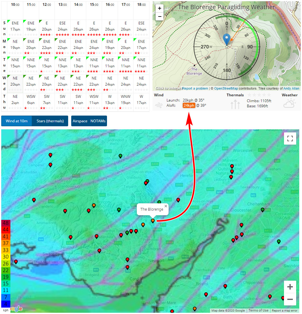
NB: Since The Blorenge is a relatively big hill (for the UK) it's likely to get blown out much sooner (with lower wind speeds) than a much smaller hill. It would most likely be blown out in the example above, for example!
Airspace & NOTAMs
It's also possible to display airspace or/and NOTAMs on the map and download the current airspace/NOTAM selection, ready to add to your flight instrument.
NB: Airspace and NOTAMs are included on FBW as a navigational aid, and to raise awareness of these in the free-flight community. No guarantees are given as to the accuracy of this airspace and NOTAM data. While we've tried to make this data as accurate as we can there may well be errors. Never forget, good airmanship is always fully YOUR responsibility. You only have yourself to blame if you go somewhere you shouldn't while using this or any other non-official data.
Airspace
Tap the Airspace button to show the overlay, then increase the height to show relevant info up to this height.
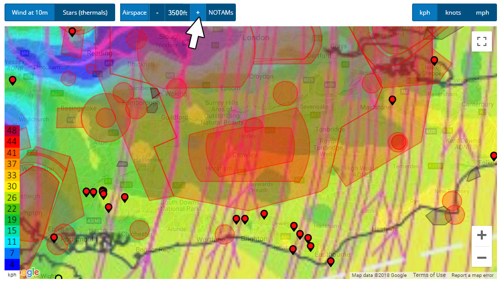
For XC flying, the minimum recommendation is 3500 ft, but if the day is good you'll need to check higher.
In the example above, most of the sites near Brighton have no XC potential because the wind direction will take you straight into the big red prohibited airspace areas around the London airports.
Leaving the airspace layer activated helps you identify the best XC opportunities as you move through the week.
NOTAMs
Once you've decided on your site and day, make sure you tap on the NOTAM button to get a complete picture of the airspace. NOTAMs (or 'notices to airmen') are temporary additional airspace restrictions, usually covering a small area over limited time periods. They are very important! Often warning you of skydiving activity, formation flights, unmanned aircraft, lazer testing, you name it. Things you're better off avoiding.
Flybubble Weather will detect any non-free-flight NOTAMs that cover your site when you're on the Site Detail page, and you'll see a handy warning pop up. Click on the grey, red or green NOTAM area to get more information. For example:
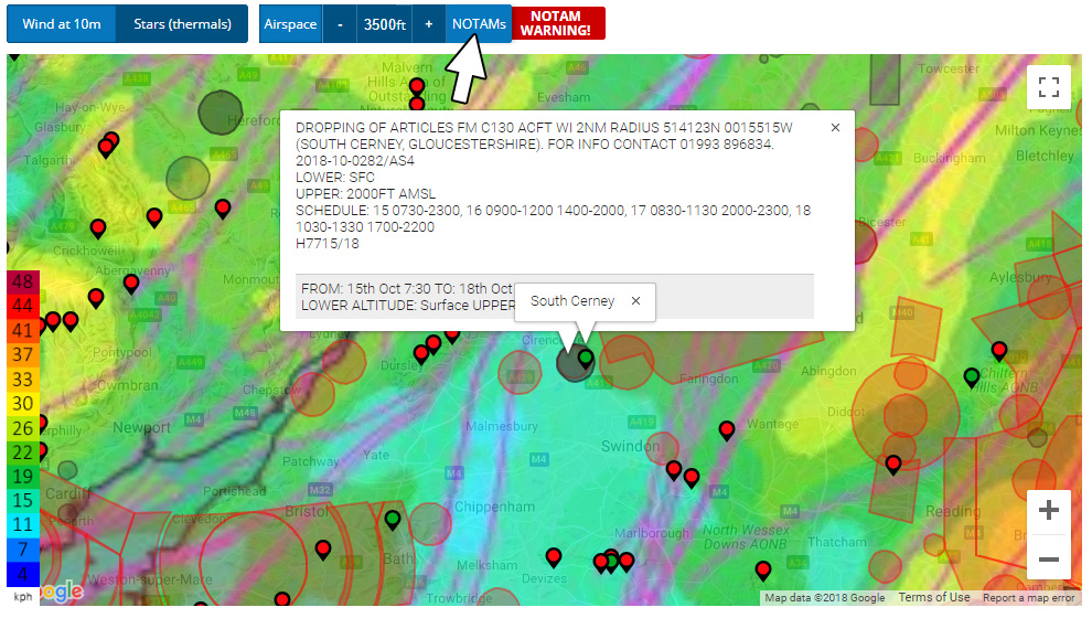
As general rules, grey NOTAM areas are usually for navigational information and should be avoided if possible—if in doubt, avoid—whilst red NOTAM areas are prohibited areas which must always be avoided.
Green NOTAMs areas indicate midweek free-flight activities, which don't trigger warnings on FBW. free-flight NOTAMs can be easily submitted by paraglider and hang glider pilots using the excellent 'CANP for free fliers' website, as explained below.
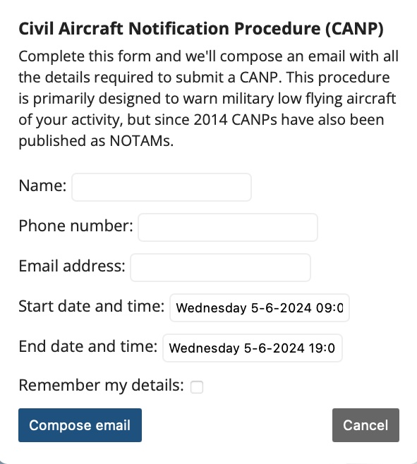
Flying during the week? Use the 'CANP for free fliers' website
Let the military (including the Royal Air Force) know you (or friends) plan to fly during the week using the CANP for free fliers website, linked to on each page of FBW. NB: This should only be done for midweek flying, not for weekends.
CANP: Civil Aircraft Notification Procedure.
Post a CANP
If it's looking good for any day other than today you can quickly and easily post a Civil Aircraft Notification Procedure (CANP) through Flybubble Weather.
Simply click the 'Post a CANP' button on the site page and we'll open your default email software with an email ready to send! Once sent, your CANP will be added as a NOTAM so other pilots know where you're flying.
XC Planner integration
We've integrated Tom Payne's XC Planner app into Flybubble Weather, on both the overview page and flying site pages. To use it, click the blue XC Planner button:
![]()
Using the XC Planner integration you can plan your XC on the map, with or without airspace or/and NOTAMs displayed.
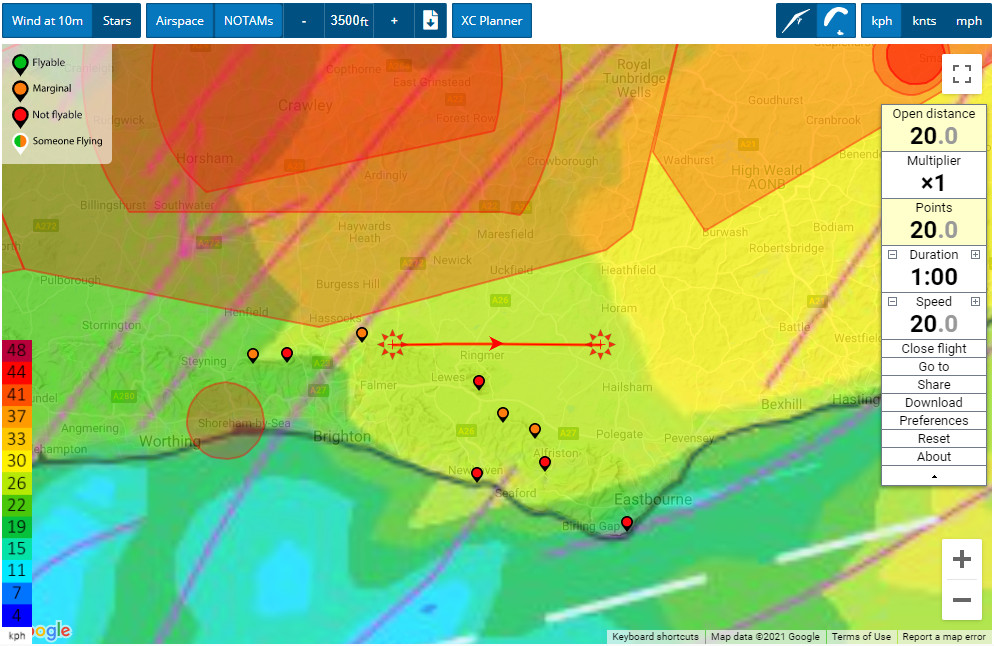
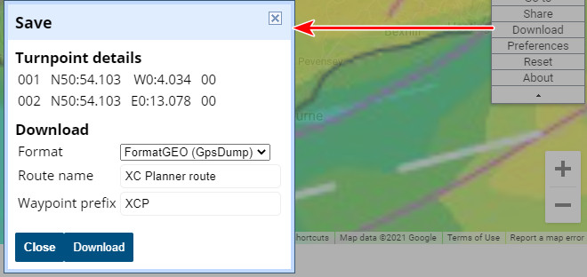
Once you're happy with your plan, you can download your XC route in various file formats, ready to add to your flight instrument. Click Download in the XC Planner panel.
Please note, we cannot offer any support for this bonus XC Planner integration since it's a third party app. Thanks to Tom Payne.
More info on a flying site?
If you are going somewhere new, you are required to do some research. Most flying sites are privately owned land with negotiated access conditions. If you Google "Paragliding [site name] site guide" you will usually find the local free-flight club responsible for controlling access. Getting in touch with the locals is a great way to avoid risks and make friends.
NB: The inclusion of a site on our website in no way gives you permission to fly it, for site info find the local club.
Which sites are best for big XC?
To help identify flying sites with good cross country (XC) potential, and see what's possible from them, check out PG XC Flight Browser, a paragliding XC data visualisation and analysis site created by Neil Charles.
Flybubble RASP server
To bring Flybubble Weather users even more reliable free-flight soaring forecasts, we took the plunge and created our very own Flybubble RASP server. This turned out to be quite an undertaking! We also found out that, to cope with the massive amount of data processing involved, the level of required server is significantly more expensive than expected! We've certainly noticed the difference, with significantly improved performance, and fewer issues. We hope you have too.
Flybubble Weather is scheduled to collect and process RASP data twice a day. Generally we serve up a fresh flying forecast for you every morning (around 7am) and evening (around 7pm). So you know how current the data is, we've added the last updated date to the top fight of the page e.g. "Updated: 06:50 22-08-2021" as shown below (desktop screen).
![]()
If it looks like one of the forecasts failed you might have to wait for the next slot.
Feedback and suggestions
This is a labour of love for us and we're always working on making it better because we want you to fly more. We've updated a lot of site information and continually improve the system as we receive feedback and suggestions.
The site database needs updating, and will improve with time. If you'd like to help, get in touch.
Tip: Sometimes the pins go clear and the time slots will show ‘No data', especially when RASP data being processed early in the morning. Please be patient, as soon as the new spot data is provided we update Flybubble Weather. In the meantime, use the coloured maps (which update first) to puzzle it out for yourself.
What's next?
We will continue to enhance the flying forecast tool, and welcome your suggestions. It is currently restricted to the UK as it benefits from the RASP forecast model which we have found to be excellent for paragliding and hang gliding.
We hope you get lots more airtime with Flybubble Weather
It's what Flybubble is all about: helping you fly more, safer and better!
https://youtu.be/L9Dp70AGkUg
Brought to you by Flybubble
Like what we do? The best way to support us is to buy gear from us and recommend us to others, thank you!