
I first noticed the SYS'Nav after Andrew Craig's review in Skywings Magazine. It's easy to overlook this diminutive instrument because of its size and remarkably low price.
The more I used it, the more impressed I became. It leads the mid-range-instrument field, and threatens some of the high-end instruments too, offering a powerful navigation solution based on minimalism and simplicity.
It's exceptionally light, but feels sturdy enough to tolerate the usual flying abuse. Because of this, it's ideally suited to being strapped onto the base of your riser, where it provides the most visible position of any instrument I've flown with, with the added benefit of reduced screen glare. Unless the sun is really low in the sky you're unlikely to get a reflection, unlike the things on your flight deck. When placed beside other instruments the SYS'Nav screen was easy to read in sunlight, and for low-light situations (?) there is an optional backlight.
On the riser, the buttons are also very easy to find and press, so shifting between the various screens was obvious and effortless, even while holding the brakes in a turn. The thoughtful product design soon becomes evident. Want the beeping to stop on launch? Just press the red button (sound mute). It is details like this that make the unit stand out – the user interface has been studied, simplified, and it really works!
In flight
I found the SYS'Nav to be a welcome relief from complexity. There are many instruments available these days with a plethora of information boxes. Every box adds something that on its own seems useful but it's easy to overpopulate your screen with things, because you might need them. This adds a mental load on the pilot, and makes it harder to find the info you need while thermaling with three hang glider pilots in strong crosswind on a ridge and the sun in your eyes.
The limited space on the SYS'Nav forced me to think very clearly about my information priorities. And it made me simplify my needs: Heading and speed; altitude and remaining altitude to airspace ceiling; average vario; windspeed and direction. That's what I need most, and it all fits on the screen with wonderful clarity.
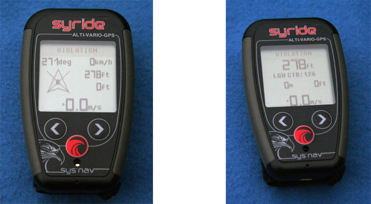
A second screen displays the details of the nearest airspace, for when I'm on glide and can process the info (violation! I live in Gatwick CTR). The map screen displays the task and terrain, with four zoom levels which I found perfect, instead of the usual endless zooming of other instruments. I could navigate around airspace and orient myself relative to the ridge nicely.

The low UK terrain soon disappeared from view as I climbed, because the unit currently only displays terrain above your altitude. Although it might be nice to be able to lower this filter, it would complicate the map screen by shading most of it over, so the current solution is well-considered. I am confident that if asked, Syride would implement any change they thought it was in the best interest of their customers.
Customisation
Although it works well as supplied, it is worth spending a little time to customise the unit.
There are two tools for this. The SYS'PC tool you load on your PC. Thereafter, whenever you plug the SYS'Nav in (USB) and turn it on, the tool will pop up, giving you options to download your flights and just about anything you'd want to do.
Option>Setup>Instrument>Change Parameters gives you access to all the details that make the instrument come alive.
The first thing I did was change the vario from instant to averaged, my logic being that you don't want to watch the instant reading because you get that information from the audio (so you can watch the traffic around you). But you want an averager to help you analyse broken lift, and it should match your circling time (in my case 15 seconds), so you can judge if you shifted your circle the right way when optimising your climb and following shifting cores.
I also changed the over-sensitive chirping vario to 'smooth' which was a closer match to the other instruments I tested it against. The SYS'Nav performed very well - it was sensitive (it beeps early) and reliable (it matched other top instruments), with the only curiosity being an occasional break in its audio description of continuous lift. Overall it's chirpy, chatty and very accurate. The thermal buzzer will also indicate the presence of weak lift, if you need it.
The second tool for customising the SYS'Nav is the SSC Tool which enables redesign of the screens. As with all things on the website, this tool is well designed and very simple to use.
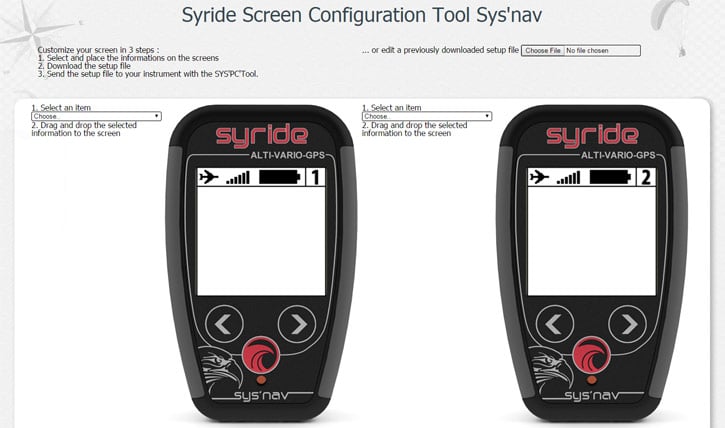
It took me about 20 minutes to think my way through what I wanted on each screen, move things around until they displayed with maximum clarity, then upload them to the device with one click.
Updating the airspace was very simple, there's a helpful file provided for each country of Syride's major markets, but it seems you'll need to check in regularly to get the latest file (the SYS'Nav itself does not seem to auto-update). Topography is similarly simple, get the file, use the SYS'PC tool to put it on the device, and hey presto, you have your height above ground wherever you are!
The Route Maker is spartan and adequate for simple routes (and again, very simple to upload to the device), but when setting myself a 50km triangle I found it lacked airspace display and FAI cones. It would be nice if Syride could bring in the features of XCplanner (http://xcplanner.appspot.com/), which give you the ability to plan around airspace and optimise your triangle. Maybe in a future version? [ed: Markus Brosch says: "Just use xcplanner and export as KML and import directly as a route into Sys'Nav, works perfectly!"]
Battery life
To test the 20h battery life claim, I flew and drove continuously for 4 hours. The battery indicator showed 80% which was spot on. I connected the SYS'Nav via USB cable to download my flight, spent a few minutes pottering around, and the tiny battery was fully recharged! Clever. It happens in the background during your normal use.
Software
Whenever I plugged the SYS'Nav in, the PC tool popped up. It took me a while to realise the large picture of the world and a green arrow was a download button I was supposed to click. When I did so, the flights jumped into a neat folder on my PC, and uploaded themselves to the Syride flight server where I was logged in automatically and was presented with a flight logbook, complete with flying stats (hours, distance, flights) and wing tracker (hours, flights). Wow! That is so helpful. I'm not very good about logging my flights but the information is relevant, and the flights are nice to see. It takes the complexity out of submitting flights to leagues: I suspect that many pilots don't care much about the leagues themselves, they just want to see their flights and review the day. With the Syride system, you don't have to lift a finger, it's presented before your eyes, and on record for later review.
Technical Support
Outstanding! If any issues are identified, Syride fixes them almost instantly, and the team behind these instruments is very smart.
During my investigations, Syride corrected a time-slip error and changed their altitude from a clever but not-well-understood GPS-baro-hybrid to Pressure Altitude only (once the SYS'Nav has auto-calibrated itself on launch site using the GPS) to harmonise with other freeflight instruments. It correctly calculates flight levels using standard atmosphere, altitude using QNH and above-ground-level airspace using the topography. I cannot fault the instrument or the service in any way.
Come on, there must be some criticism?
If you are flying far through complex airspace you might want a larger screen for mapping display, and the ability to 'tap and interrogate' an unknown obstacle, but then you're looking at high-end instruments with more weight and power consumption, or a smartphone/tablet setup. Even if you have a mapping instrument, the SYS'Nav makes an excellent affordable backup unit, with a dependable and UK-XC-League-compliant tracklog. And because it's fully functional, it gives you the added bonus of being able to switch off the power-hungry screen on your other mapping device (or the whole unit) until you really need it. You'll probably find yourself enjoying the simplicity of the SYS'Nav, which brings you back to the most important part ... flying!
Conclusion
The SYS'Nav will satisfy a very broad range of pilots. It is suitable for beginners, with its sensitive chirpy vario, simple information display, and clear wind indicator. As you develop as a pilot you'll be glad of all the extra features you can access, when you need them. The ability to strap it on the riser makes it more versatile, especially for pilots who don't want instrument decks. It's ideal for hike-and-fly enthusiasts and bivi pioneers. It caters for a big portion of the cross-country pilot market, falling short only on complex airspace display. It even throws some heavy punches in the competition flying arena, where the optimised route and glide to goal will see you finishing many tasks.
With the latest firmware update, Syride have added a 'return to last thermal' function, which makes it complete. It has, in my opinion, blown the competition out of the water in the mid-range instrument market, while being by far the lightest and most affordable. No mean feat.

"Complete, practical, powerful, lightweight?" Yes, indeed.