The SYS'Nav V3 is a mid-range flight instrument aimed at competition and cross country pilots, sitting in the Syride range under the full graphical display SYS'Evolution, and above the SYS'GPS. I'm coming to review the SYS'Nav having used the SYS'GPS instrument for the last couple of years and finding it to be excellent at what it does.
Form
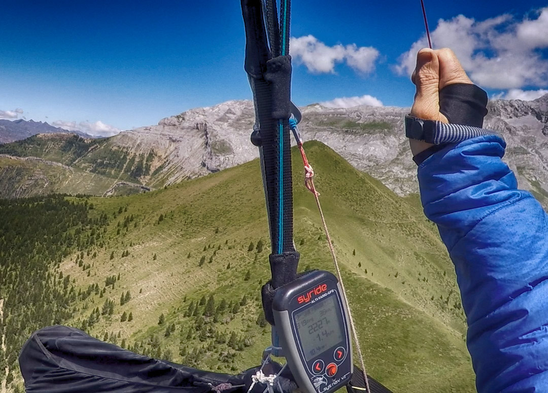
First thing to note with this instrument is the casing, it is notable both for its size and its mounting location, both features of which are one of the most attractive aspects of the Syride range. The SYS'Nav is very light at only 90 grams, small, and mounts on the riser with a strong hook and loop fastening. This location is excellent, probably better even than a head up display, and given that my Ozium harness is very short on cockpit space an alternative mounting location is my only option for a back-up instrument. I much prefer this to a wrist or thigh mount.
On the down side, strapping the instrument to the riser does leave the instrument in a slightly vulnerable location when your kit is on the ground (my SYS'GPS survived well for a long time, but eventually did get stepped on, squishing a few of the instrument pixels. It survived this abuse well enough to still be usable though, so the instrument is robust.) One way around this would be to demount after each flight.
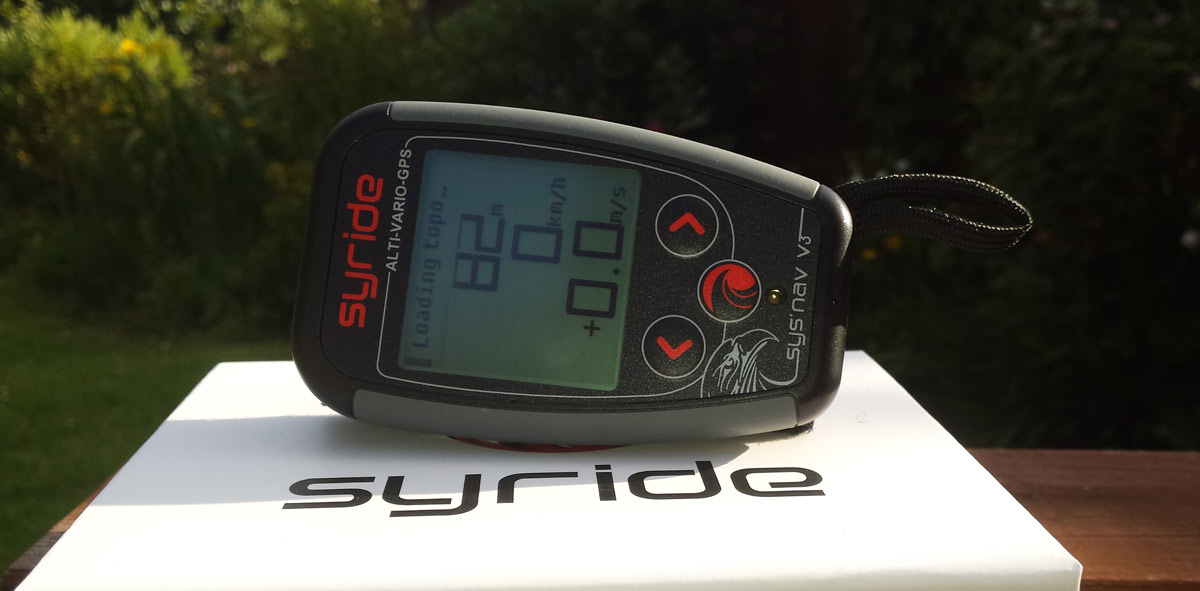
The case is solid and satisfying to the touch, the packaging is very high quality also and the instrument comes with a slick carry case if you like to use one.
On the SYS'GPS the battery life is great at 40-hours autonomy, which has proved plenty long enough to stay charged for many flights and still be good for a 100 km plus flight, even if you take off with less than 25% battery left. The SYS'Nav is good for 45 hours, so even better and another plus point.

PC Interface
Connecting the instrument to your PC requires a download of the Syride SYS PC Tool, giving the ability to customise many aspects of the device. I've found the tools to be very good – intuitive and well presented.
The Syride website has a range of tools, which for the SYS'Nav include:
- Screen Configuration (SSC) – this allows customisation of the four main flight screens
- Topography map creator – (The V3 is already preloaded with global topography)
- Airspaces – to allow a download of airspace files
- Route Maker – to allow the creation of a navigation route
- Sound Config –to allow a change of the tone frequency
It's possible to play with these without first having bought the instrument, which might be worthwhile if you wish to research before a purchase, you can find them here.
If you have an account with Syride there is also a cloud based online database of your personal flight log information, which I particularly like as it gives a nice presentation of my individual flights, plus aggregate statistics for each year of both kilometres and hours flown.
Screens
The screens are highly configurable. Out of the box the screens display:
- First: displays height, speed and the vario in large font.
- Second: direction in degrees, glide ratio, height ASL and ground height ASL.
- Third: a visual compass ‘strip', G meter, temperature, time and duration of flight.
- Fourth: distance to the next waypoint, and distance from take-off.
- Fifth: a map display at a scale of 4 km (zoomable).
Every screen also displays a prominent airspace warning along the top.
As he is (still!) a better pilot than me, I used Greg's screen set up file which gives a far more useful presentation.
Vario
As a pure vario the SYS'Nav works very well. One thing I noticed when flying was that the vario on the Nav consistently read higher than the GPS by quite a margin: this was cured by amending the vario sensitivity settings.
The vario options are highly configurable from a single setting screen with all the usual options, including a smoothing function for the vario reactivity and a neat function for sniffing lifty air where the instrument buzzes at a sink rate of just below 0.
The same setting screen allows you to set the horizontal and vertical airspace warning alarm, G force alarm, the vario averaging time and glide ratio averaging time.
Navigation
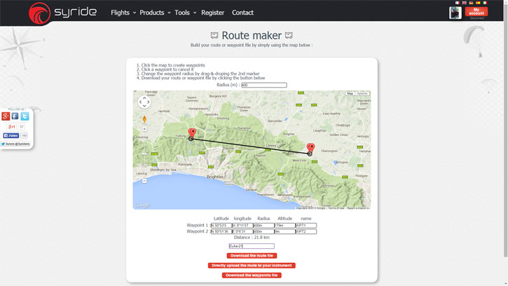
Although you can you can load, create, edit or delete a route and waypoints on the instrument itself, it's much easier to load a route first created on the Syride web interface. The Route maker tool is very intuitive and quick to create a route, once done you can then download the route file to your PC or upload it directly to the instrument with the SYS'PC software.
The instrument is pre-loaded with a topographic map of the world (a step forward from the SYS'GPS). Without connecting to a PC, entering information on the device is very slow with just three keys, but it can be useful to amend routes or enter waypoints on the hill if necessary, for which you will need the GPS coordinates.
I've used the SYS'Nav as a secondary navigation instrument as a backup to an XCSoar device. In this application, it is particularly useful as it allows me to only fire up the XCsoar program when airspace is imminent. An added bonus for UK XC league purposes is that it creates valid G-records (track) and C-records (tasks) for entering flights into the XC leagues, thereby saving a manual declaration.
The SYS'NAV V3 minimalist setup: phone for airspace, V3 for everything else
In Use
Syride recommend it can take up to 10 minutes to get a GPS fix after a significant change in location (i.e. going abroad or driving to remote site) so therefore recommend turning the instrument on 10 minutes before use.
The buttons are large and easy to use in winter gloves. I do find it a bit too easy to turn the instrument off in flight as this function is only one button click away from muting the instrument, so this is one issue to be wary of.
As noted, the screen presentation is very easy to read, having 4 screens (versus only 2 on the SYS'GPS) means available screen real estate is larger so you can use larger font sizes. Unlike XCSoar, there is no auto-switching of screens for circling or final glide, but I don't miss it.
Being a navigation-based instrument there is a thermal sniffer, thermal core dot and a last thermal indicator, all useful functions.
As I am something of a luddite (who'd be happier having been born a seagull without needing electronics at all) another great feature I really like is that there is no need to set actual QNH pressure, because it reads altitude from both a GPS fix and a barometric pressure reading the instrument can do this for you, waiting until it has a sufficiently accurate GPS reading then calibrating the barometric pressure reading automatically.
Overall it provides the basic information I need really well, with a clear visible display and easy switching. I don't need complexity when it comes to staying airborne, finding thermals and flying safely. It displays the distance to the nearest airspace ahead and above you. This is adequate if you already know the layout of your local airspace, as it also provides a simplified view on the map screen. But for cross country flying there's no way I can remember all the complex shapes we have to avoid in the UK, so for that there's nothing like a wide screen device (XCSoar or Oudie) where you can touch the various blocks and investigate what's coming up.

Even the pros agree, there's nothing quite like it when you want to go lightweight
Conclusion
As you may have gathered, I'm a huge fan of the features, simplicity and form of the SYS'Nav V3.
The balance of small size, low weight, great simplicity and rich features makes the Syride SYS'Nav V3 a really useful piece of kit. I fully expect to be happy using it for many years to come.
I can conclude that Syride have fulfilled their own brief for the SYS'Nav V3 extremely well. It's a great price given the functionality and convenience offered. Well done Syride!
Find out more about the Syride SYS'Nav V3