On Friday 4th July 2008 Carlo Borsattino, Chief Flying Instructor (CFI) of Flybubble Paragliding, launched his paraglider from Mount Caburn hill on the South Downs hills near Lewes in East Sussex and flew 'cross country' (XC) for four and a half hours, climbing to nearly 5000 ft above sea mean level (AMSL), eventually landing safely at the edge Sheerness town on the Isle of Sheppey, a very happy man indeed.
Carlo flew part of this flight with his paragliding friends Paul Andon, Matt Pepper, Jon Fox, Charlie Merrett and Richard Chester Nash.
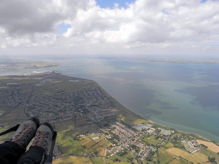
His flight took him over or near Glynde village, Glynde Opera House, Ringmer, Ripe, Laughton village, Laughton forest, East Hoathly, Halland, Heathfield, Etchinham, River Rother, Burwash, Ticehurst, Bewl Water, Darwell Reservoir, Bedgebury Forest, Hawhurst, Tenterden, Iden Green, Biddenden, Headcorn (keeping out of the airspace, of course), Bethersden, Ashford, the M20, the North Downs, the M2, Faversham, The Swale, and of course Sheerness on the Isle of Sheppey.
Most ground observers would not have even noticed Carlo's paragliding flight as he flew silently overhead, as it was done without an engine or fuel. Instead he used the natural power of the atmosphere, warm rising air currents, called thermals, to gain altitude, climbing up to the fluffy white cumulus clouds thousands feet up, and the wind to help carry him along as he glided from one cumulus to another.
He landed safely at the edge Sheerness town, rather than continuing on, because he didn't have enough height to cross the Thames River from the Isle of Sheppey. He tried to fly west, towards the Isle of Grain, but didn't quite make it to the next thermals.
As well as an up-to-date CAA air navigation chart, Carlo flew with a Garmin Global Positioning System (GPS) and a Flytec flight instrument called a variometer (vario) on this flight which helped him navigate his way around airspace restrictions and make better use of the thermals etc. These flight instruments also record a three dimensional (3D) GPS 'tracklog' which you can see overlaid on various maps, courtesy of Memory-Map software.
Hear an audio podcast (opens in new browser window) interview with Carlo and two other paraglider pilot friends who flew from Mount Caburn on the same day, Matt and Paul. This interview is aimed at qualified paraglider pilots who are interested in flying cross country and understand paragliding terminology.
Photo story 2008.07.04
As the views were so incredible, Carlo took many photos during his paragliding flight from Mount Caburn on the South Downs to the Isle of Sheppey
Some of the photos include names of other paraglider pilots flying, place names, and explanations of what was happening during the flight at the time.
[justified_image_grid rml_id=267]